


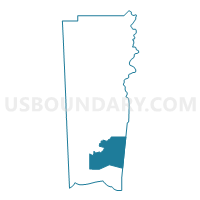
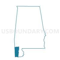
St. Michael Catholic Church, Mobile County, Alabama
About
Outline

Summary
| Unique Area Identifier | 522598 |
| Name | St. Michael Catholic Church |
| County | Mobile County |
| State | Alabama |
| Area (square miles) | 129.11 |
| Land Area (square miles) | 27.96 |
| Water Area (square miles) | 101.15 |
| % of Land Area | 21.65 |
| % of Water Area | 78.35 |
| Latitude of the Internal Point | 30.33923790 |
| Longtitude of the Internal Point | -88.12823420 |
Maps

Graphs
Select a template below for downloading or customizing gragh for St. Michael Catholic Church, Mobile County, Alabama


Neighbors
Neighoring Voting District (by Name) Neighboring Voting District on the Map
- Barnwell Community Center, Baldwin County, AL
- Bon Secour Morgan's Chapel, Baldwin County, AL
- Coden Community House, Mobile County, AL
- Dauphin Isl. Baptist Resort, Mobile County, AL
- Fort Morgan VFD Station #2, Baldwin County, AL
- Magnolia Springs Wesleyan Church, Baldwin County, AL
- Odd Fellows Hall, Mobile County, AL
- St Philip Neri Church, Mobile County, AL
Top 10 Neighboring County Subdivision (by Population) Neighboring County Subdivision on the Map
- Foley CCD, Baldwin County, AL (48,089)
- Fairhope CCD, Baldwin County, AL (25,894)
- Theodore CCD, Mobile County, AL (23,380)
- Bayou La Batre CCD, Mobile County, AL (10,209)
Top 10 Neighboring Place (by Population) Neighboring Place on the Map
Top 10 Neighboring Unified School District (by Population) Neighboring Unified School District on the Map
Top 10 Neighboring State Legislative District Lower Chamber (by Population) Neighboring State Legislative District Lower Chamber on the Map
- State House District 95, AL (61,642)
- State House District 94, AL (59,763)
- State House District 105, AL (44,279)
Top 10 Neighboring State Legislative District Upper Chamber (by Population) Neighboring State Legislative District Upper Chamber on the Map
Top 10 Neighboring 111th Congressional District (by Population) Neighboring 111th Congressional District on the Map
Top 10 Neighboring Census Tract (by Population) Neighboring Census Tract on the Map
- Census Tract 73, Mobile County, AL (4,439)
- Census Tract 71.03, Mobile County, AL (3,390)
- Census Tract 72.01, Mobile County, AL (2,999)
- Census Tract 72.02, Mobile County, AL (2,771)
- Census Tract 9900, Baldwin County, AL (0)
- Census Tract 9900, Mobile County, AL (0)